
 Water samples taken at Lion’s Head Beach show results within acceptable levels, according to Ministry of Health and Long-Term Care standards.The Grey Bruce Health Unit took samples on Tuesday, August 26, 2014. Based on these results, the beach, which was posted as unsafe on August 20, 2014, is now deemed safe for bathing.
Beach water sampling from Tuesday, August 26, 2014, at Kincardine Station Beach and Black Creek (also known as Old Woman’s River) (Northern Bruce Peninsula) shows bacterial levels exceeding Ministry of Health and Long-Term Care standards. As a result, these areas will be posted and remain posted until samples indicate that water is safe for bathing.
The Medical Officer of Health advises bathers that high levels of bacteria in the water may pose a risk to their health.
Beach information on our website is updated as conditions change. For more information, please call 519-376-9420 or 1-800-263-3456 or visitwww.publichealthgreybruce.on.ca.
For more information:
Andrew Barton
Grey Bruce Health Unit
519-376-9420 or 1-800-263-3456 ext.1353
Dude, Where's My Beach?
As summer cottagers began their vacations, some had to wonder where their beach had gone. Particularly in dune areas, the shoreline appeared to be overtaken with dune grasses. What actually happened was a confluence of natural processes.
After Lake Huron’s last high lake level in 1997, water levels dropped dramatically in 1998 and stayed well below average for nearly a decade and a half. With the low levels came wide expansive beaches. These open sandy beaches were prone to wind erosion, and sand was blown and deposited into the dunes as part of their natural re-building process.
Marram grass, a dominant dune grass on Lake Huron beaches, has its growth rate stimulated by sand burial. The wide open beaches created an opportunity for the grass to grow lakeward. That’s a good thing. If it didn’t grow lakeward, causing the dune to grow wider, the dune would instead grow higher and people would be living beside a vertical wall of sand. Most dunes instead grow wider, toward the lake, building up the sand reserve that helps protect the shore and maintain good quality beaches once higher lake levels return.
Over the past one and a half years, lake levels have rebounded impressively, rising nearly a metre since the record low in 2013. The wet fall, winter and spring contributed to levels continuing to rise well into July.
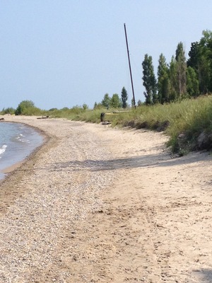
For cottagers, the timing was a bit off. The dunes that had grown lakeward for the past number of years was being met with a rising shoreline, leaving little open sand on which to lay a beach towel. But Mother Nature eventually puts things right. Open beaches are open because of an important process: storm waves. The reason we have open beaches at all is because of storm wave activity. If that were not the case, we would have forests growing right up to the water’s edge.
So the lack of beach in some areas this summer is a matter of timing. Our storm season is still ahead of us. The gales of November produce substantial storm wave energy that causes shore erosion, and the fall and winter storms should open up the beaches again. Unless, of course, lake levels keep rising. But then you’ll be glad you have those dunes for protection and for sand supply for your beach!
[article by Geoff Peach, Coastal Resources Manager]
Lake Turnover - a natural process, or a tasty dessert?
What is meant by "lake turnover"? How and why does Lake Huron do this in autumn and spring?
The key to these questions is how water density varies with water temperature. Water is most dense (heaviest) at 4º C and as temperature increases or decreases from that temperature, it becomes increasingly less dense (lighter). In summer and winter, lakes are maintained by climate in what is called a stratified (or layered) condition, where less dense water is at the surface and more dense water is near the bottom.
During late summer and autumn, air temperatures cool the surface water causing its density to increase. The heavier water sinks, forcing the lighter, less dense water to the surface. This continues until the water temperature at all depths reaches approximately 4º C. Because there is very little difference in density at this stage, the waters are easily mixed by the wind. The sinking action and mixing of the water by the wind results in the exchange of surface and bottom waters which is called "turnover."
During spring, the process reverses itself. This time ice melts, and surface waters warm and sink until the water temperature at all depths reaches approximately 4º C. The sinking combined with wind mixing causes spring "turnover."
The layering and turnover of water annually are important for water quality. Turnover is the main way in which oxygen-poor water in the deeper areas of the lakes can be mixed with surface water containing more dissolved oxygen. This prevents anoxia, or complete oxygen depletion, of the lower levels of most of the lakes. Which is good! However, the process of stratification during the summer also tends to restrict dilution of pollutants from effluents and land runoff. Which is not so good.
During the spring warming period, the rapidly warming nearshore waters are inhibited from moving to the open lake by a thermal bar, a sharp temperature gradient that prevents mixing until the sun warms the open lake surface waters or until the waters are mixed by storms. Because the thermal bar holds pollutants nearshore, they are not dispersed to the open waters and can become more concentrated within the nearshore areas.
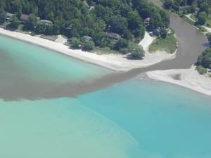
Scientists studying the effects of climate change on the Great Lakes are discovering that water temperatures of the Great Lakes are increasing because of the warmer summer air temperatures and longer ice-free season. Warmer waters could affect the timing and frequency of lake turnover. In a warmer climate, the turnover may not occur every year in all lakes. Turnover is the main way for deeper lake waters to become replenished with oxygen, and without enough dissolved oxygen, cold water lake fish and other species would be unable to survive in their deep water habitats.
More on Lake turnover - click here.
Have a Guilt-Free Labour Day
Ah, Labour Day. The last long weekend in the year when people go to the beach to forget about work. That may be great for most people. But at the Coastal Centre...the beach is where we work! That's OK. Don't feel guilty. We love what we do. However, if you're sitting on the beach, with a refreshing beverage, thinking, 'those poor super heroes at the Coastal Centre, working to make this beach I'm sitting on so awesome, what can I do to help them?' Well, be guilty no more! You can donate to the Centre...your local beach protectors!
You can donate online through CanadaHelps, or send a donation cheque by mail. For more information on donating to the Centre, visit our donate page.
 News Release
For Immediate Release
September 11, 2014
Beach Postings Removed, Beaches Safe for Bathing
Water samples taken at Black Creek (also known as Old Woman’s River), Northern Bruce Peninsula and Station Park Beach, Kincardine, show results within acceptable levels according to Ministry of Health and Long-Term Care standards.
The Grey Bruce Health Unit took samples on Monday, September 8, 2014. Based on these results, the beaches, which were posted as unsafe on August 28, are now deemed safe for bathing.
Although this latest sample result shows acceptable results, the public is reminded that water conditions can change quickly. High winds and heavy rain are likely to have an adverse impact on water quality.
Beach information on our website is updated as conditions change at: Current Status Listings
For more information:
Andrew Barton
Manager, Safe Water
Grey Bruce Health Unit
519-376-9420 or 1-800-263-3456 ext.1353
a.barton@publichealthgreybruce.on.ca
Crying Over Spilled Oil
Oil disasters like the Exxon Valdez and Deep Water Horizon are nightmares that we on the Great Lakes have not had to worry about. At least not yet.
But recent developments in the oil transportation industry compel us to pay attention to proposed and existing oil routes in the Great Lakes region.
In Lake Huron, existing oil pipelines cross the lake bottom in the Straits of Mackinac, and the St. Clair River at Sarnia. Both lines are now transporting crude oil from the Alberta oil sands. That’s different than the regular crude that previously flowed through these lines. Oil sands crude is heavier, and if it gets into water will sink to the bottom. That makes it much tougher to clean up in the event of a spill. And that should be concerning for us in the Great Lakes region who preside over 20% of the planet’s fresh water.
University of Michigan researchers recently modelled what a spill would look like if caused by a pipeline break in Mackinac. The results would impact pristine ecosystems, and would be extremely challenging to clean up.
Meanwhile, a proposal has been made to develop a port in Superior, Wisconsin that would enable shipment of oil by tanker through the Great Lakes. While the issue is currently on hold, it may be just a matter of time before it gets a green light.
Of course, it’s easy to envision the possibility of an oil spill in the abstract, and hypothesize that a cleanup would be extraordinarily challenging. But we’ve had a recent dose of reality. The pipeline break in the Kalamazoo River in 2010 spilled over 3 million litres of oil into this Lake Michigan tributary. Four years later, the cleanup goes on.
A report by the Alliance for the Great Lakes details the issue of oil transport through the Great Lakes, and outlines many of the shortcomings that we have here in our ability to respond to environmental emergencies, such as spill cleanups.
U.S. Coast Guard officials admit that the region is ill-prepared to deal with a spill of heavy oil on the Great Lakes. This, along with federal cuts to Environmental Emergencies' capabilities recently, makes the situation a serious concern. We in the Great Lakes should expect much better contingency and response planning. Our two federal governments have already spent billions since the 1970s trying to clean up toxic 'hot spots' around the basin. We shouldn't burden our children and grandchildren with more toxic legacies that result from poor foresight.
Going Up!
Levels have continued to climb on Lake Huron. And they are climbing at a time when the seasonal decline is expected. Typically on Lake Huron, the annual lake level trend is to reach a low point in February, begin to rise as snow melt and spring rains flow to the lake. The rise typically continues until early July, and then levels decline during the remainer of the year.

This year, levels continued to rise into July, August and September. September levels usually decline fairly dramatically as cooler air begins to blow over warm lake water. This usually draws water levels downward due to higher rates of evaporation. This year, however, September was cool and wet, and the lake was relatively cool as well. A decrease in evaporation, coupled with inflows from rain and inputs from Lake Superior have kept levels climbing.
Lake levels on Huron have risen sharply from their record lows in January 2013. Since then, levels have risen around one metre, adding about 53 trillion litres to Lakes Michigan-Huron (the two lakes are hydrologically connected through the deep Straits of Mackinac, so they behave as one single lake).
Read more on how Lake Huron has risen to its highest point in 15 years here.
Halloween and Beaches
What kind of witch likes to sunbathe at the beach? A Sand Witch. Like the rest of us, sand witches prefer clean, healthy beaches. That's what the Coastal Centre is all about. This Halloween, consider a donation to the Coastal Centre to support its beach conservation work. It'll be just the right potion for a Happy Halloween!
You can donate online through CanadaHelps, or send a donation cheque by mail. For more information on donating to the Centre, visit our donate page.

On behalf of the Bruce Beach Executive, I would like to wish everyone a Happy New Year and best wishes to your beach families and friends in the coming year.
"Cheers for the New Year and another chance to get it right". The year is coming to a close with a very different start to the winter, high water, big winds, no snow and warm temperatures. The last day of 2014 is the first really cold day of the winter and the beginning of the ice formations along the shoreline.
The executive have a number of items on our plate for 2015, not least of which is the continued search for a new Vice-President, a changing beach shoreline, continued focus on lake water quality, Huron-Kinloss continuing in the DGR Process for Used Nuclear Fuel, and the financial pressures on our hospital and the municipalities of Kincardine and Huron-Kinloss.
I look forward to working with all members of our association in the coming year, the other beach Presidents and the Mayor and members of Huron-Kinloss council and administration.
Eight months until the Bruce Beach BBQ, Saturday, August 1st.
Attached is a look at the beach from earlier this week.
David Grant President,
Bruce Beach Cottager's Association
139 Gordon St. N.
"Do what you can, with what you have, where you are. " Theodore Roosevelt
From: Minister, MOECC (MOECC) [mailto:Minister.MOECC@ontario.ca]
Sent: February-18-15 5:42 PM
To: Undisclosed recipients:
Subject: Great Lakes Protection ActOntario is taking action to protect the Great Lakes and has re-introduced a strengthened Great Lakes Protection Act, which recognizes the importance of the Great Lakes to Ontario’s environment, economy and health of our citizens.
If passed, the new, strengthened Great Lakes Protection Act will protect and restore our Great Lakes, to help keep them drinkable, fishable, and swimmable.
The strengthened act, if passed, would:
- Help to fight climate change, reduce harmful algal blooms, and protect wetlands and other coastal areas
- Monitor and report on the health of the lakes
- Bring people together to take local action on priority issues
- Build on Ontario’s leadership in protecting the Great Lakes, including our Great Lakes Strategy and partnerships with Canada, Québec, and the U.S. Great Lakes states
The proposed act reflects feedback we’ve received on previous versions of the bill.
We encourage you to provide your comments on the Ontario Environmental Registry. Comments will be accepted until April 19, 2015.
Today’s action builds on the recently signed Canada–Ontario Agreement on Great Lakes Water Quality and Ecosystem Health which is the principal mechanism through which Ontario and Canada coordinate their work to address their respective and shared commitments to protect the Great Lakes. The proposed Great Lakes Protection Act also builds upon Ontario’s Great Lakes Guardian Community Fund which was established to help people take action to protect and restore their corner of the Great Lakes.
If you have any questions or would like more information please email Chris Lompart.
I look forward to continuing to work with you to protect our Great Lakes now, and for future generations.
Sincerely,
Glen Murray
Minister
The Great Plastic Lakes
Plastic pollution in the Great Lakes is something we’ve reported on in past editions of E-news. It’s a story in which the Coastal Centre made national news coverage in 2010 when plastic pellets began appearing on Lake Huron beaches. The story was covered on CBC’s The National, The Globe and Mail, Vancouver Sun, and many media outlets across the country. It was a story that caught people’s attention as they wondered why plastics were appearing in Lake Huron and then began asking about the scope of the problem.
As more research was done to look closer into the issue, it became increasingly clear … plastic in the Great Lakes was becoming an emerging issue bigger than most people could imagine. U.S. researchers began trolling the waters of the open lakes and found alarming concentrations of micro-plastics (small particles less than 5 mm. in diameter) floating in the water. Some of these micro-plastics were discovered to have originated from cosmetic products, like soaps, exfoliating creams, toothpaste, and other common products. These barely visible particles (termed micro-beads) were concerning because they were so small, they were passing through filters at sewage treatment plants and getting into the lakes. Neither Canada, nor the United States, has regulations affecting sewage plant discharge of micro-plastics.
Politicians have become aware of the issue. Two U.S. states (Illinois and New Jersey) have already passed legislation banning products with plastic microbeads. Bill 75, The Microbead Elimination and Monitoring Act, has been introduced in Ontario and has passed second reading. The Coastal Centre has written to the Minister of the Environment and Climate Change in support of this Bill. In addition to the proposed provincial legislation, a federal motion was made in Parliament to consider these micro-plastics to be a toxic substance.
In addition to the above, the Coastal Centre also reviewed data on plastic material gathered during beach cleanups. The range and amount of plastic litter on Lake Huron beaches was significant. In 2014, for example, community volunteers helped remove over 10,000 plastic articles from nearly 40 kilometres of beaches. The articles ranged from small fragments to larger ones, including intact beach toys and disposable plastic water bottles. The number one litter item was cigarette filters, which are composed of plastic fibres.
To gain a better perspective on the magnitude of the plastic pollution issue, the Coastal Centre partnered with a team of graduate students from Western University. The report from this analysis can be found here.
Most recently, a research team from the University of Waterloo published an article titled, “Plastic Debris in the Laurentian Great Lakes: a Review” in the Journal of Great Lakes Research. It looks at all available data, threats to the lakes ecosystems, including links to human health.
Some of the threats raised include:
Micro-plastics act as a sponge that can absorb toxins, like PCBs and heavy metals.
- Plastic can become ingested by aquatic wildlife, which can cause malnutrition, and accumulation of toxins in tissues.
- Fish and birds can become entangled in plastic fishing lines and nets that have been discarded or lost in the lake.
- Plastic can take thousands of years to degrade. In the meantime, accumulations of plastic in the lake environment could become very costly to clean up.
To move toward addressing at least part of this issue, the Coastal Centre, with funding from the provincial Great Lakes Guardian Community Fund, will begin a beach clean-up campaign in selected communities along Lake Huron. The aim will be to encourage communities to participate in local beach clean-up programs, connected to the national Great Canadian Shoreline Clean-up program, that measure and analyze the plastic debris collected and report back to the community. This is debris that gets discarded by people, and burdens communities with collection, clean-up and landfill costs. This Centre project is aimed toward building some awareness of the issue, and encouraging active involvement in local solutions along the coast.
This spring, Coastal Centre staff worked with Bruce Power and the Bruce County Museum to deliver the Bruce Power Eco-Mentors Program. Coastal Centre staff taught students in Bruce County about plastic pollution and responsible waste management. This educational unit was made possible through funding from Bruce Power, and helped begin the awareness of the prevalence of this issue on our local shores.
In the longer view, the economic and environmental costs of plastic pollution will hopefully compel residents in the Great Lakes to re-examine their relationship with plastic, in what we use and what we buy.
Article by Geoff Peach, Coastal Resources Manager
More on Plastics in the Great Lakes – NOAA Technical Memorandum on Marine Debris Action Plan in the Great Lakes
Coastal Centre to Public: “Get Your Butts Off Our Beaches”
There. We said it. We want your butts off Lake Huron’s beaches. Permanently.
We probably should have prefaced the above comments by indicating that we are referring to cigarette filters. Our apologies for the double entendre.
That fact of the matter is that cigarette filters are the top waste discarded on our beaches. And further to our previous article on plastic, it should be known that cigarette filters are composed of plastic fibres. So, these butts are adding to our micro-plastic pollution problem. Not only that, but these filters pose a risk to shore wildlife who mistake the filters for food, and to the younger humanoids that play on our beaches, who can be exposed to toxins within the filters. Most would agree that this waste has no business being on our beaches.

(Coastal Centre staffs nephew surrounded by butts (red circles) on the beach, summer 2014. The butts were removed from his hands seconds before he tried to taste them.)
This summer, the Coastal Centre will be taking its “Butt Free Beach” campaign to Sarnia’s Canatara Park, Goderich waterfront beaches and Sauble Beach. People visiting these communities will be greeted with information signs that explain the concerns with cigarette filters on beaches, and makes available cardboard ash trays that form into cones that the user fills with sand to extinguish their butts, and when they are done, pours the sand out of the funnel end of the cone leaving the butts in the cone. Then the user can take the filters to the nearest waste receptacle for proper disposal as they leave the beach.
“Butt Free Beach” was first piloted by the Coastal Centre last summer at Grand Bend and Kincardine. The results were very positive among users, and brought a greater awareness of the issue to many beach-goers.
For more information on the Coastal Centre’s Butt Free Beach program, click here.
Victoria Day, Water Quality and the Coastal Centre
Victoria Day weekend is the traditional start of the cottage season on Lake Huron. Many people commemorate this event by enjoying their favourite beverage. The basis of all quenchables, whether it’s beer coolers, lemonade or even the ice you use to chill it, is WATER. We depend on good water quality for our beverages, and we work, as one of our four priorities, to protect water quality. Ergo, the Coastal Centre protects the quality of your beverages. (Do you like how we constructed that logic?)
To help ensure the future quality of your libations, consider a donation to the Coastal Centre to help our conservation work. Paying it forward for a good drink.
To make a donation click here.

Cutting Trees from Bluff Slopes Somebody Didn't Get the "MEMO"
TO:  Inexperienced Lakeshore Landowners

FROM:  The Coastal Centre
DATE:  June 2015
SUBJECT:  Stop Clear Cutting Trees from Bluffs
It’s a recurring issue: clear-cutting trees from bluff slopes along the Huron County shoreline. It suggests that there are still a few people who haven’t gotten the memo. So here it is. Again!!!
Clear cutting trees from a bluff slope to gain a better view of the lake will lead to erosion, possibly even catastrophic slope failure.
 Now here’s why:
The science is in. There is a cause and effect relationship between woodland clear cutting and mass slope failure.
Cutting of trees on slopes leads to a gradual decrease in stability as a result of the decay of roots that previously acted as tensile reinforcements in the slope. Root decay can also lead to the formation of underground crevices and channels, called "pipes" in a slope that promote erosion by groundwater seepage. Groundwater seepage is often a catalyst for large scale slope failures. Seepage of groundwater from a bluff is very complex, and very expensive to attempt remediation.
The removal of tree canopy results in the loss of evapo-transpiration (trees expel a lot of groundwater through their leaves). The loss of trees tends to promote wetter and less secure slopes. Removal of tree cover (canopy) also results in the direct impact of rainfall to the soil surface, since the tree cover protects the soil by intercepting rain drops before they hit the surface. Trees also help to reduce surface water runoff velocities, which can erode soil from the face of the slope.
One of the troubling things about the removal of large number of trees from coastal slopes is that it typically takes 8 to 10 years for roots to decay, removing that critical stabilization benefit. This long time period can lead people to believe initially that no harm has been done. But the adverse effects become evident several years later, and the resulting erosion cannot only affect the property on which the trees were removed, but affect neighbouring properties as well.
What to do if you want a view:
-
Forget about that panoramic vista that you’ve seen on postcards. It doesn’t work well on Lake Huron. The trees provide stability to the slope, increasing the lifespan of your property.
-
You can establish a lake view by opening up a “window,” selectively cutting tree branches. You’ll get a view, but also retain the trees for slope stability and wind protection.
-
Hiring a qualified arborist is likely worth the investment to make sure the work is done safely, and without any collateral damage.
-
Read more on bluff stewardship here.
-
For information on current shoreline regulations and by-laws, contact your local conservation authority or municipality.
The Coastal Centre has a large array of shore-related information available to all shoreline landowners, but particularly valuable to newcomers to Lake Huron. Understanding our lake and coastal processes is a good investment for long, happy enjoyment of your property.
Article by Geoff Peach, Coastal Resources Manager
Be Careful Out There
With beach season underway, being aware of potential dangers is important to a safe and relaxing day on the shore.
We’ve talked before about rip currents in past issues, but it’s good to remind yourself of what they are, where they might occur and how to escape if you get caught in one. Check out the Centre’s Beach Safety page, and learn simple tips at the Be Current Smart website. Structures, such as piers and jetties, are notorious places for dangerous currents to occur. Many drownings have occurred around these kinds of structures. Check out this video, “In Over Your Head: a 3-step process for saving your life.”
Be cautious of water temperature. Extensive ice cover over the past couple of winters means that the lake will take longer to warm up. Cold water can zap your energy quickly, and can lead to hypothermia. Know where to find lifesaving equipment at the beach. Certified Blue Flag beaches are required to have life saving equipment. Only a small number of public beaches on Lake Huron have qualified lifeguards on duty (Sarnia, Goderich Rotary Cove and Grand Bend).
Water quality information is usually available online through local Public Health Units. Links to area Health Units can be found on our Beach Safety page. SwimGuide is a Smart Phone app that may be a useful tool, too.
Oui, We
This June 24, celebrate St. Jean Baptiste Day. He is the patron saint of coastal stewardship. At least, I think I read that somewhere.
To honour this saint, consider donating to the Coastal Centre. We do coastal stewardship. Oui, we!
To make a donation click here.
Looks Like a Good Day to Swim, or Is It?
We often get calls every summer from people wondering if it’s safe to swim at one particular beach or another. It can be a tricky question, since water quality testing is not universal. What you may think is a public beach might not be considered to be “public” by local public health authorities interpreting provincial guidelines. Plus, current water testing techniques take water samples, test them in the lab, and produce results usually 24 hours after taking the sample. Conditions can change quickly in 24 hours, so a good test result taken on a Friday doesn’t necessarily mean that swimming on a Saturday is in the same quality of water. A rainfall or increase in wave activity can alter water quality results quickly.
So there are several tools you can use to better inform yourself about the best places to go for a swim. A relatively new way in Ontario is to locate a “Blue Flag” beach. Many beaches on Lake Huron have what is referred to as a Blue Flag designation. This is an international program intended to identify beaches that have met a certain set of water quality, environmental, and safety criteria. Going to one of these beaches can at least assure you that a certain standard is being met, and that there is some third-party oversight in how the beach is being managed.
Another way is to use the SwimGuide app for Smartphones. This is a resource that uses water quality data from public health authorities around the Great Lakes. Again, test results are only as good as the conditions under which the samples were taken.
Public Health Units also post swimming guidelines on their websites. We have linked to the relevant Lake Huron health units on our website here. Each unit determines where it does water testing, so never assume a beach is being tested just because there are a lot of people using it. And while water test results may be out of date before you step in the water, they are useful when the data are taken over a longer time period (several days or weeks) if they show a trend, whether it be good or bad. Some agencies in the US have been working on models to help speed up the process of providing beach quality information to the public by synthesizing testing data with lake conditions.
While apps and flags and test data can help you on your way to determining a safe choice, an additional method to help you verify a good swimming site is to observe conditions. If it has rained in your area within the last couple of days, chances are that bacteria levels will be higher. This is particularly true in places where agriculture is a predominant land use. Wavy conditions should also tell you that lake bottom and beach sediments, which can harbour pathogens like E. coli., have been stirred up and re-suspended in the water. Rule of thumb: If you can wade in up to your waist and still see your feet, it should be OK to swim.
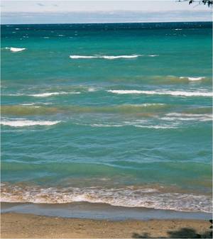
There are numerous agencies and organizations in the Lake Huron region working to improve water quality in the Lake Huron watershed. It’s a long and ongoing process. While progress is being made, some people still don’t get it. Whether it’s leaving dog feces on the beach, or ignoring a malfunctioning septic system, there is still much work to do in linking personal responsibility with lake quality. So while people want assurance of water safety, good, consistent water quality on Lake Huron will take time and cooperation.
So, if you're a beach goer looking for a good place to swim, using some good judgement, and the above tools, you can make an informed choice for you and your family. And one day, with everyone’s help, Lake Huron’s waters will be, without question, the best and cleanest in Ontario.
Article by Geoff Peach, Coastal Resources Manager
My Beach is Still Missing, Dude
As a sequel to the original “Dude, Where’s My Beach” article from last year, this article provides an update to lake level conditions.
Last year, we explained that the lack of walkable beaches was due to rapidly rising lake levels, converging with vegetation growth that had aided the build-up of dunes and beach sand over the preceding 14 years of below-average lake levels. We forecast then that fall storms and wave erosion would help readjust beaches, barring any further increases in lake levels. Well, as it happened, levels continued to increase, and beaches remained narrow this summer. In fact, a doubling of June’s average precipitation over the region caused Lake Huron’s levels to increase in July and into August, when typically early July is the start of the decline in the annual cycle.
Levels are over 30 centimetres above what they were at this time last year. And where levels typically begin to decline over summer months, their continued rise means narrow beaches continue to narrow. Where levels will go from here is anyone’s guess, but beaches will continue to adjust as waves erode the shore and move sand around. The dune erosion that occurs provides sand to the beach and nearshore lakebed, and this helps to lessen the wave energy that erodes the shore. The build-up of sand in the dunes that occurred over the past 14 years is providing the shore protection we need now.
So, dude, how wide your beach is next summer will depend on what happens during the storm season this fall, and whether water levels continue to climb. Levels will climb if we continue to receive high amounts of precipitation, and lower evaporation if lake water remains cool and we get another cold, icy winter.
Background:
Lake Michigan-Huron, (these 2 lakes behave as one big lake hydrologically), saw a rise in water levels from the record-low experienced in January 2013 through December 2014. It was a remarkable one metre increase that almost tied the record rise set in 1950-1951.
Perspective
As we reach the first of August, some might lament that the summer is half over. But we say “we’ve got half the summer left!” That’s the kind of positivity the Centre uses to approach its conservation work. How can you go wrong donating to an organization that works on hope and optimism, founded on science and informed stewardship?
A donation to the Coastal Centre is a positive, life-affirming act of greatness.
To make a donation, click here.