

Looks Like a Good Day to Swim, or Is It?
We often get calls every summer from people wondering if it’s safe to swim at one particular beach or another. It can be a tricky question, since water quality testing is not universal. What you may think is a public beach might not be considered to be “public” by local public health authorities interpreting provincial guidelines. Plus, current water testing techniques take water samples, test them in the lab, and produce results usually 24 hours after taking the sample. Conditions can change quickly in 24 hours, so a good test result taken on a Friday doesn’t necessarily mean that swimming on a Saturday is in the same quality of water. A rainfall or increase in wave activity can alter water quality results quickly.
So there are several tools you can use to better inform yourself about the best places to go for a swim. A relatively new way in Ontario is to locate a “Blue Flag” beach. Many beaches on Lake Huron have what is referred to as a Blue Flag designation. This is an international program intended to identify beaches that have met a certain set of water quality, environmental, and safety criteria. Going to one of these beaches can at least assure you that a certain standard is being met, and that there is some third-party oversight in how the beach is being managed.
Another way is to use the SwimGuide app for Smartphones. This is a resource that uses water quality data from public health authorities around the Great Lakes. Again, test results are only as good as the conditions under which the samples were taken.
Public Health Units also post swimming guidelines on their websites. We have linked to the relevant Lake Huron health units on our website here. Each unit determines where it does water testing, so never assume a beach is being tested just because there are a lot of people using it. And while water test results may be out of date before you step in the water, they are useful when the data are taken over a longer time period (several days or weeks) if they show a trend, whether it be good or bad. Some agencies in the US have been working on models to help speed up the process of providing beach quality information to the public by synthesizing testing data with lake conditions.
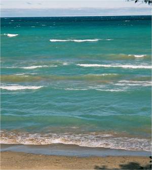
While apps and flags and test data can help you on your way to determining a safe choice, an additional method to help you verify a good swimming site is to observe conditions. If it has rained in your area within the last couple of days, chances are that bacteria levels will be higher. This is particularly true in places where agriculture is a predominant land use. Wavy conditions should also tell you that lake bottom and beach sediments, which can harbour pathogens like E. coli., have been stirred up and re-suspended in the water. Rule of thumb: If you can wade in up to your waist and still see your feet, it should be OK to swim.
There are numerous agencies and organizations in the Lake Huron region working to improve water quality in the Lake Huron watershed. It’s a long and ongoing process. While progress is being made, some people still don’t get it. Whether it’s leaving dog feces on the beach, or ignoring a malfunctioning septic system, there is still much work to do in linking personal responsibility with lake quality. So while people want assurance of water safety, good, consistent water quality on Lake Huron will take time and cooperation.
So, if you're a beach goer looking for a good place to swim, using some good judgement, and the above tools, you can make an informed choice for you and your family. And one day, with everyone’s help, Lake Huron’s waters will be, without question, the best and cleanest in Ontario.
Article by Geoff Peach, Coastal Resources Manager
My Beach is Still Missing, Dude
As a sequel to the original “Dude, Where’s My Beach” article from last year, this article provides an update to lake level conditions.
Last year, we explained that the lack of walkable beaches was due to rapidly rising lake levels, converging with vegetation growth that had aided the build-up of dunes and beach sand over the preceding 14 years of below-average lake levels. We forecast then that fall storms and wave erosion would help readjust beaches, barring any further increases in lake levels. Well, as it happened, levels continued to increase, and beaches remained narrow this summer. In fact, a doubling of June’s average precipitation over the region caused Lake Huron’s levels to increase in July and into August, when typically early July is the start of the decline in the annual cycle.
Levels are over 30 centimetres above what they were at this time last year. And where levels typically begin to decline over summer months, their continued rise means narrow beaches continue to narrow. Where levels will go from here is anyone’s guess, but beaches will continue to adjust as waves erode the shore and move sand around. The dune erosion that occurs provides sand to the beach and nearshore lakebed, and this helps to lessen the wave energy that erodes the shore. The build-up of sand in the dunes that occurred over the past 14 years is providing the shore protection we need now.
So, dude, how wide your beach is next summer will depend on what happens during the storm season this fall, and whether water levels continue to climb. Levels will climb if we continue to receive high amounts of precipitation, and lower evaporation if lake water remains cool and we get another cold, icy winter.
Background:
Lake Michigan-Huron, (these 2 lakes behave as one big lake hydrologically), saw a rise in water levels from the record-low experienced in January 2013 through December 2014. It was a remarkable one metre increase that almost tied the record rise set in 1950-1951.
Perspective
As we reach the first of August, some might lament that the summer is half over. But we say “we’ve got half the summer left!” That’s the kind of positivity the Centre uses to approach its conservation work. How can you go wrong donating to an organization that works on hope and optimism, founded on science and informed stewardship?
A donation to the Coastal Centre is a positive, life-affirming act of greatness.
To make a donation, click here.

On behalf of the Bruce Beach Executive, I would like to wish everyone a Happy New Year and best wishes to your beach families and friends in the coming year.
"Cheers for the New Year and another chance to get it right". The year is coming to a close with a very different start to the winter, high water, big winds, no snow and warm temperatures. The last day of 2014 is the first really cold day of the winter and the beginning of the ice formations along the shoreline.
The executive have a number of items on our plate for 2015, not least of which is the continued search for a new Vice-President, a changing beach shoreline, continued focus on lake water quality, Huron-Kinloss continuing in the DGR Process for Used Nuclear Fuel, and the financial pressures on our hospital and the municipalities of Kincardine and Huron-Kinloss.
I look forward to working with all members of our association in the coming year, the other beach Presidents and the Mayor and members of Huron-Kinloss council and administration.
Eight months until the Bruce Beach BBQ, Saturday, August 1st.
Attached is a look at the beach from earlier this week.
David Grant President,
Bruce Beach Cottager's Association
139 Gordon St. N.
"Do what you can, with what you have, where you are. " Theodore Roosevelt
Crying Over Spilled Oil
Oil disasters like the Exxon Valdez and Deep Water Horizon are nightmares that we on the Great Lakes have not had to worry about. At least not yet.
But recent developments in the oil transportation industry compel us to pay attention to proposed and existing oil routes in the Great Lakes region.
In Lake Huron, existing oil pipelines cross the lake bottom in the Straits of Mackinac, and the St. Clair River at Sarnia. Both lines are now transporting crude oil from the Alberta oil sands. That’s different than the regular crude that previously flowed through these lines. Oil sands crude is heavier, and if it gets into water will sink to the bottom. That makes it much tougher to clean up in the event of a spill. And that should be concerning for us in the Great Lakes region who preside over 20% of the planet’s fresh water.
University of Michigan researchers recently modelled what a spill would look like if caused by a pipeline break in Mackinac. The results would impact pristine ecosystems, and would be extremely challenging to clean up.
Meanwhile, a proposal has been made to develop a port in Superior, Wisconsin that would enable shipment of oil by tanker through the Great Lakes. While the issue is currently on hold, it may be just a matter of time before it gets a green light.
Of course, it’s easy to envision the possibility of an oil spill in the abstract, and hypothesize that a cleanup would be extraordinarily challenging. But we’ve had a recent dose of reality. The pipeline break in the Kalamazoo River in 2010 spilled over 3 million litres of oil into this Lake Michigan tributary. Four years later, the cleanup goes on.
A report by the Alliance for the Great Lakes details the issue of oil transport through the Great Lakes, and outlines many of the shortcomings that we have here in our ability to respond to environmental emergencies, such as spill cleanups.
U.S. Coast Guard officials admit that the region is ill-prepared to deal with a spill of heavy oil on the Great Lakes. This, along with federal cuts to Environmental Emergencies' capabilities recently, makes the situation a serious concern. We in the Great Lakes should expect much better contingency and response planning. Our two federal governments have already spent billions since the 1970s trying to clean up toxic 'hot spots' around the basin. We shouldn't burden our children and grandchildren with more toxic legacies that result from poor foresight.
Going Up!
Levels have continued to climb on Lake Huron. And they are climbing at a time when the seasonal decline is expected. Typically on Lake Huron, the annual lake level trend is to reach a low point in February, begin to rise as snow melt and spring rains flow to the lake. The rise typically continues until early July, and then levels decline during the remainer of the year.

This year, levels continued to rise into July, August and September. September levels usually decline fairly dramatically as cooler air begins to blow over warm lake water. This usually draws water levels downward due to higher rates of evaporation. This year, however, September was cool and wet, and the lake was relatively cool as well. A decrease in evaporation, coupled with inflows from rain and inputs from Lake Superior have kept levels climbing.
Lake levels on Huron have risen sharply from their record lows in January 2013. Since then, levels have risen around one metre, adding about 53 trillion litres to Lakes Michigan-Huron (the two lakes are hydrologically connected through the deep Straits of Mackinac, so they behave as one single lake).
Read more on how Lake Huron has risen to its highest point in 15 years here.
Halloween and Beaches
What kind of witch likes to sunbathe at the beach? A Sand Witch. Like the rest of us, sand witches prefer clean, healthy beaches. That's what the Coastal Centre is all about. This Halloween, consider a donation to the Coastal Centre to support its beach conservation work. It'll be just the right potion for a Happy Halloween!
You can donate online through CanadaHelps, or send a donation cheque by mail. For more information on donating to the Centre, visit our donate page.
Thank you for coming to speak with Council and share your thoughts on September 15th, 2014.
Attached please find a letter from the Clerk containing the response from Council regarding the state of the lakeshore in the Bruce Beach area.
Joanna Malott
Deputy Clerk/ Administrative Assistant
Township of Huron-Kinloss
21 Queen St., Box 130
Ripley, ON N0G 2R0
 Hello David and Ross
The state of the beach in front of our cottage has prompted me to contact the H-K office about a solution. Our beach is so narrow that if there is any wave action one must walk in the water to get past the growth of grass and weeds that has left a three foot cliff along the waters edge. After repeated e-mails to Mayor Mitch Twolan ( mitch@lakerangerealty.ca ) he finally arranged for Mike Fair to come and see my concern and listen to my suggestions. Have you ever talked to a wall?
After showing him the cliff along our lakefront held there by not just beach grass but small tree roots, and many weeds of dubious origin, he stated the Ministry of Natural Resources has forbidden the use of power equipment on the beach. It is his theory that the rising water levels will eventually wash away the grass and weeds and render the beach passable. He stated that we had the same problem five years ago and the the rising water took care of the situation when, in fact, it was the lower lake level that gave us a semblance of beach for a few years.
I inquired as to why Kincardine Station Beach is permitted to use power equipment to groom the beach and we are not. He agreed it happens but that he had no idea as to why it is allowed.
I suggested that even the ministry is capable of changing its mind if encouraged to do so and that government is not infallible, i.e. Orange, gas plants, hydro, etc. He wasn’t inclined to pursue their stand on power equipment on the beach. He insists that higher water levels will break down the grass, weed and sand banks over time.
If you are as offended by the state of the beach, the beach grass and foreign mater growing along the waters edge as I am I encourage you to write Huron-Kinloss Township and encourage them to do something about the restriction on clearing the debris away from the waterfront even to the point of allowing us to bring in power equipment. www.huron-kinloss.com
Join the crusade to return Bruce Beach to its past state of being a sand beach we are all able to enjoy.
One angry Beach-Bum!
Dude, Where's My Beach?
As summer cottagers began their vacations, some had to wonder where their beach had gone. Particularly in dune areas, the shoreline appeared to be overtaken with dune grasses. What actually happened was a confluence of natural processes.
After Lake Huron’s last high lake level in 1997, water levels dropped dramatically in 1998 and stayed well below average for nearly a decade and a half. With the low levels came wide expansive beaches. These open sandy beaches were prone to wind erosion, and sand was blown and deposited into the dunes as part of their natural re-building process.
Marram grass, a dominant dune grass on Lake Huron beaches, has its growth rate stimulated by sand burial. The wide open beaches created an opportunity for the grass to grow lakeward. That’s a good thing. If it didn’t grow lakeward, causing the dune to grow wider, the dune would instead grow higher and people would be living beside a vertical wall of sand. Most dunes instead grow wider, toward the lake, building up the sand reserve that helps protect the shore and maintain good quality beaches once higher lake levels return.
Over the past one and a half years, lake levels have rebounded impressively, rising nearly a metre since the record low in 2013. The wet fall, winter and spring contributed to levels continuing to rise well into July.
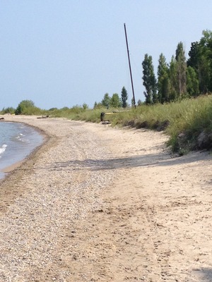
For cottagers, the timing was a bit off. The dunes that had grown lakeward for the past number of years was being met with a rising shoreline, leaving little open sand on which to lay a beach towel. But Mother Nature eventually puts things right. Open beaches are open because of an important process: storm waves. The reason we have open beaches at all is because of storm wave activity. If that were not the case, we would have forests growing right up to the water’s edge.
So the lack of beach in some areas this summer is a matter of timing. Our storm season is still ahead of us. The gales of November produce substantial storm wave energy that causes shore erosion, and the fall and winter storms should open up the beaches again. Unless, of course, lake levels keep rising. But then you’ll be glad you have those dunes for protection and for sand supply for your beach!
[article by Geoff Peach, Coastal Resources Manager]
Lake Turnover - a natural process, or a tasty dessert?
What is meant by "lake turnover"? How and why does Lake Huron do this in autumn and spring?
The key to these questions is how water density varies with water temperature. Water is most dense (heaviest) at 4º C and as temperature increases or decreases from that temperature, it becomes increasingly less dense (lighter). In summer and winter, lakes are maintained by climate in what is called a stratified (or layered) condition, where less dense water is at the surface and more dense water is near the bottom.
During late summer and autumn, air temperatures cool the surface water causing its density to increase. The heavier water sinks, forcing the lighter, less dense water to the surface. This continues until the water temperature at all depths reaches approximately 4º C. Because there is very little difference in density at this stage, the waters are easily mixed by the wind. The sinking action and mixing of the water by the wind results in the exchange of surface and bottom waters which is called "turnover."
During spring, the process reverses itself. This time ice melts, and surface waters warm and sink until the water temperature at all depths reaches approximately 4º C. The sinking combined with wind mixing causes spring "turnover."
The layering and turnover of water annually are important for water quality. Turnover is the main way in which oxygen-poor water in the deeper areas of the lakes can be mixed with surface water containing more dissolved oxygen. This prevents anoxia, or complete oxygen depletion, of the lower levels of most of the lakes. Which is good! However, the process of stratification during the summer also tends to restrict dilution of pollutants from effluents and land runoff. Which is not so good.
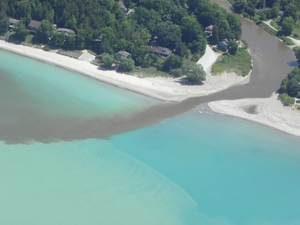
During the spring warming period, the rapidly warming nearshore waters are inhibited from moving to the open lake by a thermal bar, a sharp temperature gradient that prevents mixing until the sun warms the open lake surface waters or until the waters are mixed by storms. Because the thermal bar holds pollutants nearshore, they are not dispersed to the open waters and can become more concentrated within the nearshore areas.
Scientists studying the effects of climate change on the Great Lakes are discovering that water temperatures of the Great Lakes are increasing because of the warmer summer air temperatures and longer ice-free season. Warmer waters could affect the timing and frequency of lake turnover. In a warmer climate, the turnover may not occur every year in all lakes. Turnover is the main way for deeper lake waters to become replenished with oxygen, and without enough dissolved oxygen, cold water lake fish and other species would be unable to survive in their deep water habitats.
More on Lake turnover - click here.
Have a Guilt-Free Labour Day
Ah, Labour Day. The last long weekend in the year when people go to the beach to forget about work. That may be great for most people. But at the Coastal Centre...the beach is where we work! That's OK. Don't feel guilty. We love what we do. However, if you're sitting on the beach, with a refreshing beverage, thinking, 'those poor super heroes at the Coastal Centre, working to make this beach I'm sitting on so awesome, what can I do to help them?' Well, be guilty no more! You can donate to the Centre...your local beach protectors!
You can donate online through CanadaHelps, or send a donation cheque by mail. For more information on donating to the Centre, visit our donate page.
They're Back, Baby!

Two nests are currently at Sauble Beach, and a nest has appeared for the first time in Port Elgin, at the main beach. Wasaga Beach Provincial Park is also a nesting destination for some Plovers. The birds and their young present some challenges for beach managers and beach-goers since they do need some space to do their thing. But it is possible to beach in harmony with the little birds. It takes a bit of patience, and an understanding that these are an endangered species.
Aside from their rarity, these birds provide an indicator, or 'marker,' of good beach quality. And, as it happens, each of these three Ontario beaches have undertaken conservation measures that have improved beach sand quality and quantity, restored the natural dunes, reduced erosion and improved local water quality. So when the Piping Plover comes to nest, that tells us our shores must be doing all right.
Plover Report for Sauble Beach:
- four pairs on the beach this year.
- lost two nest to predation, possibly a weasel or mink; however, both pairs re-nested.
- the first pairs clutch hatched on July 6.
- only 2 of the 4 eggs hatched and both chicks were taken — one by a gull the first day and the other the following morning by a gull or merlin.
- there are 3 nests left on Sauble Beach and they are due to hatch July 17, 24, and 27th.
Plover Report for Port Elgin Beach:
- a total of 4 chicks hatched on June 23.
- the chicks are doing well and are starting to stretch their wings.
- they are also getting quite big now at 2.5 weeks old.
- the female and male are still caring for the chicks.
Tips for Protecting Plovers:
- stay out of fenced-off beach areas as this is important habitat for plover nesting and raising young
- keep pets off the beach, and make sure they are on a leash
- if you see a Piping plover, please keep your distance
- do not feed the gulls, as these birds will prey upon the plover’s eggs and chicks
- put your garbage in the proper receptacle. Gulls can be attracted to garbage on the beach
- look for volunteers on the beach wearing orange vests and feel free to ask questions and view the plovers with them
- if you'd like to volunteer to watch over the Plovers, contact Craig Todd at the Ministry of Natural Resources - craig.todd@ontario.ca
Learn more about Piping Plovers click here.
[article by Geoff Peach, Coastal Resources Manager]
Just Average??

Water levels on Lake Huron have been low so long, that a rebound to average conditions is a cause for celebration. Since 1998, when levels dropped dramatically, and then remained low until early last year, people have wondered if we’d ever see ‘normal’ conditions again. Well, some really wet seasons, including the large accumulations of snow and ice cover of this past winter, show how quickly things can change on such a big water body.
After an unusually cold winter in the Great Lakes region, Spring 2014 was also cooler than normal, coming in as the 5th coldest on record since 1948. Great Lakes ice cover reached 92.5% by early March, making it the second greatest amount of ice cover since record keeping began in 1973.
2014 has seen a larger-than-average seasonal lake level rise, bringing Lake Huron, to just 16 centimetres below the 1918-2013 average and making the Great Lake 35 centimetres higher than the same time last year. In January 2013, levels on Lake Huron marked a record low, 70 cm. below ‘chart datum’. Since then, the rebound has been remarkable, rising over one metre since that low point.
[Note: reliable water level records on the Great Lakes began in 1918, so the historical record typically refers to that start point. Also, from a hydrological standpoint, Lakes Michigan and Huron are considered to be a single lake, due to the deep Straits of Mackinac that connect them. The level on Lake Michigan is the same as the level on Lake Huron.]
May 2014 Water supplies were well above average during May on Lake Michigan–Huron causing this lake’s level to rise by 16 cm, double its average May increase of 8 cm and the sixth highest May rise on record
April 2014 Water supplies in April were also well above average on Lake Michigan–Huron causing this lake’s level to rise by 20 cm, nearly double its average April increase of 11 cm and the sixth highest April rise on record. Looking back to the year before, Lake Michigan–Huron’s level rose by 24 cm, more than double its average. The 24 cm increase was only 1 cm less than the record April rise of 1951
[sources: Environment Canada; US National Oceanic and Atmospheric Administration]
Lazy Days of Summer
During those hot summer days when all you want to do is lounge with a cold beverage, there aren't too many activities that will get you moving. But if you focus all of your energy, a fun activity that doesn't require you to leave your lounge — is making a donation to the Coastal Centre! You can do it the old fashioned way and write a cheque (requires about 0.032 kilo joules of energy expenditure), or the new-fangled method through your tablet or smart phone (needs about 0.026 kilo joules of energy). Either way, you won't even break a sweat. How cool is that?